1.3. Hazard Characterization
The ground motions for the Mw 7.0 Hayward earthquake were simulated by Rodgers et al. ([Rodgers19]) at the Lawrence Livermore National Lab (LLNL) using the SW4 finite difference code ([Petersson17]). SW4 solves the elastodynamic equations of motion in the time domain for a 3D solid. A 77 ~ 13 km rupture surface was projected onto the fault geometry in the 3D geologic and seismic model for the Bay Area ([USGS18]) with a hypocenter near the San Leandro salient. Waveforms were sampled in three dimensions on a 2 km grid over the 120 ~ 80 km surface of a 35 km deep solid body. The resulting waveforms capture ground shaking reliably over the 0–5 Hz frequency domain for sites with a characteristic shear wave velocity above 500 m/s. The computations were run using more than 8,000 nodes (~ 500,000 processors) on the Cori Phase-II cluster ([NERSC20]).
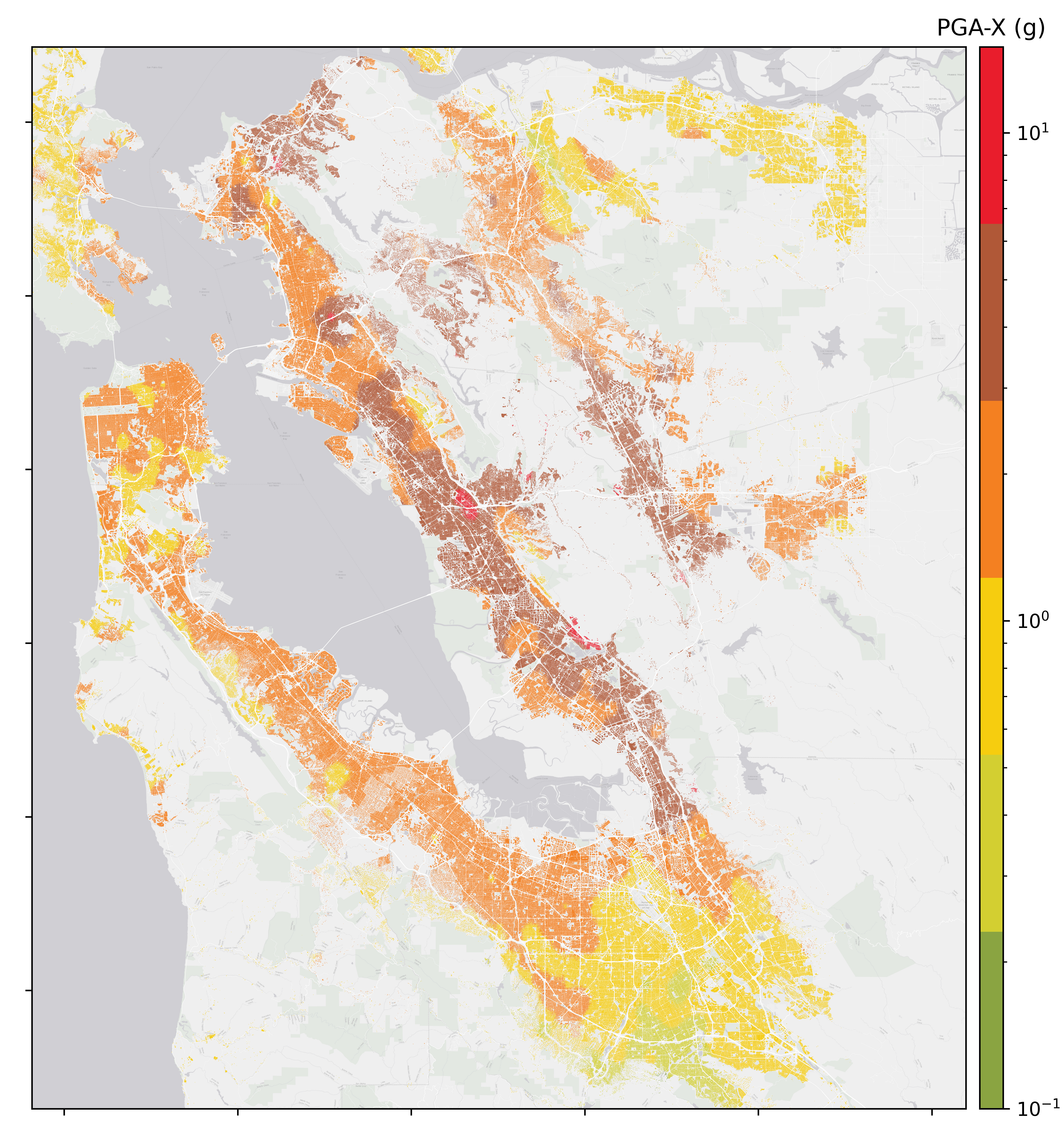
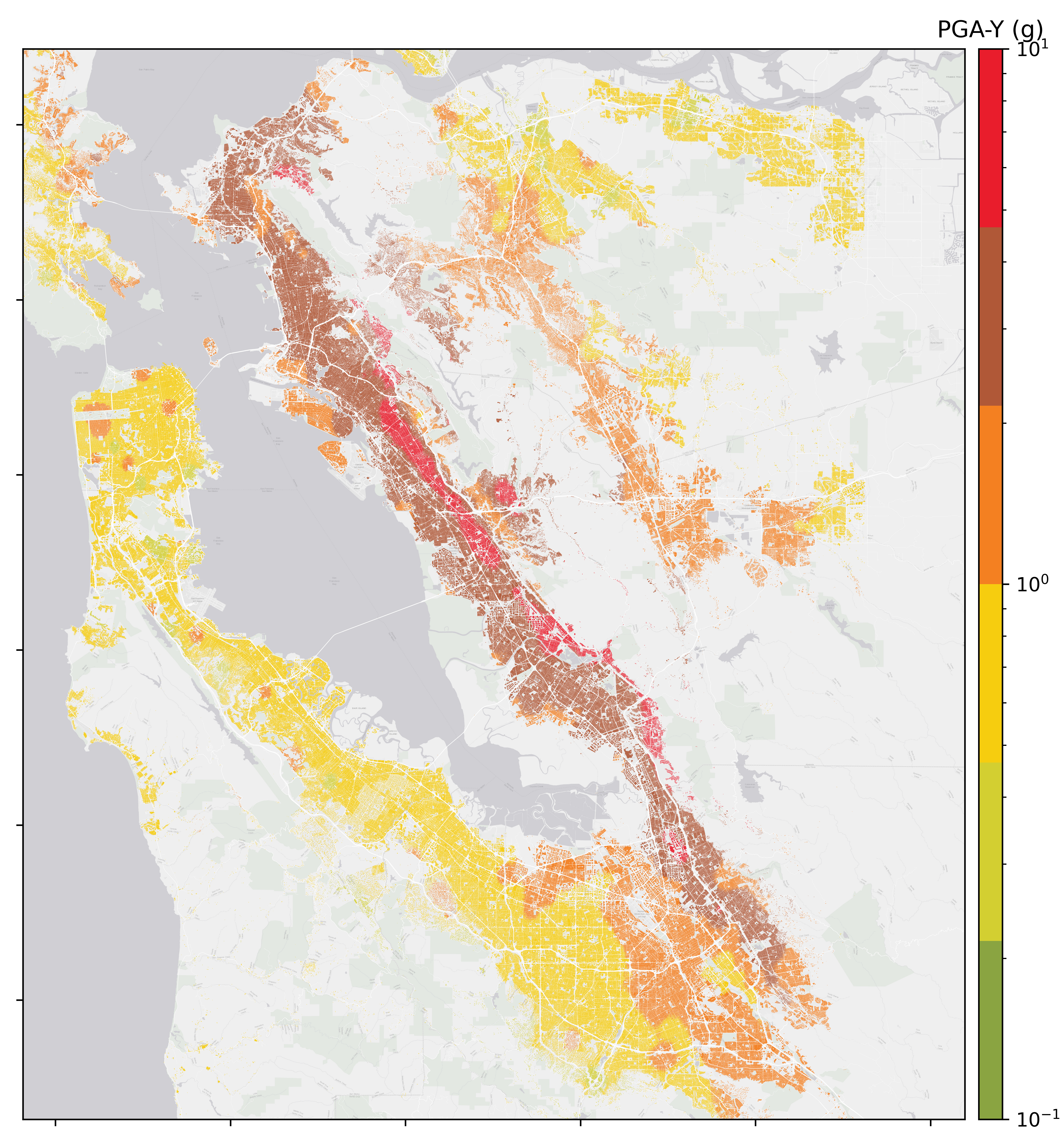
The raw results at 2301 grid points were processed by the SimCenter and converted to the JSON file format used by our workflow applications. These data provide sets of three-component seismograms for grid points spaced every 2 km throughout the study region. The ground motions are assigned to buildings using a nearest-neighbor search algorithm, where the four nearest grid points are identified for each building and a set of 25 seismograms are assigned by weighted random sampling of the set of time histories from the nearest grid points. The weight of each grid point is inversely proportional to its squared distance from the building. Fig. 1.3.1 and Fig. 1.3.2 show the resulting mean peak ground acceleration maps (in East-West and North-South directions) based on the 25 ground motions at each site.

Fig. 1.3.1 Peak ground acceleration (East-West direction) for the Mw 7.0 Hayward earthquake.

Fig. 1.3.2 Peak ground acceleration (North-South direction) for the Mw 7.0 Hayward earthquake.
Rodgers, A. J., Petersson, N. A., Pitarka, A., McCallen, D. B., Sjogreen, B., and Abrahamson, N. (2019). Broadband (0-5 Hz) Fully Deterministic 3D Ground-Motion Simulations of a Magnitude 7.0 Hayward Fault Earthquake: Comparison with Empirical Ground-Motion Models and 3D Path and Site Effects from Source Normalized Intensities. Seismol. Res. Lett. 90:17.
Petersson, N. A., and Sjogreen, B. (2017). SW4, version 2.0 [software], Computational Infrastructure of Geodynamics. Switzerland: Zenodo.doi: 10.5281/zenodo.1045297
USGS (2018). 3-D geologic and seismic velocity models of the San Francisco Bay region. Virginia, VA: USGS. https://earthquake.usgs.gov/data/3dgeologic.
NERSC (2020). Cori Cray XC 40 Computer. Berkeley: National Energy Research Scientific Computing Center. https://docs.nersc.gov/systems/cori/.